Lookout Mountain, just a few miles outside of the Chattanooga city limits, boasts countless trails and incredible views over the Tennessee River Valley. These trails range in length and difficulty, offering incredible views, a chance to explore the city’s history, and beautiful waterfalls. One of my favorite waterfall trails is the Glen Falls Trail, located off Ochs Highway in Chattanooga.
Glen Falls is less than 5 miles outside of the Chattanooga city limits, which makes it great for a quick lunch spot or post-work run/hike, and it’s a great place for kids. The trail is moderate difficulty, but is short in length, so it can be complete in less than an hour–unless you want to take the time to explore the falls and all they have to offer!
Hiking Glen Falls in Chattanooga, TN
Total Distance: 1 mile
Elevation Gain: 425′ including the upper falls
Time To Complete: One hour
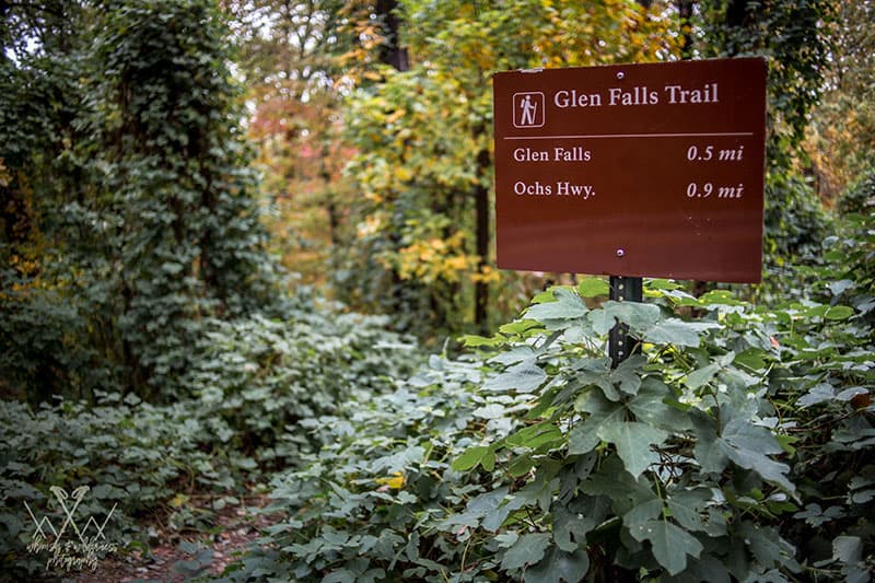
Getting to Glen Falls
To get to the trailhead, take Ochs Highway up Lookout Mountain to the intersection with Sanders Drive. The trailhead is about 100 yards past this intersection on the left, and parking is arguably the most difficult part of the whole trail.
The “parking lot” is more of a pull-off, but cars should still park perpendicular to the road, as parallel parking will only allow a few cars to park at a time. There is a small sign indicating you are in the right place, and the trail starts on the left side of the parking pull-off, leading to a kiosk a few feet down with a map of the trail.
The Trail
After passing the map, the trail descends for about a quarter of a mile. This stretch has a lot of rocks and roots which can make finding your footing difficult, and very young kids and toddlers may need help so they don’t stumble.
Soon the trail levels out, crossing a seasonal stream and winding through a deciduous forest. Large boulders become more frequent to the right, while the left side of the trail drops off quickly the closer you get to the falls.
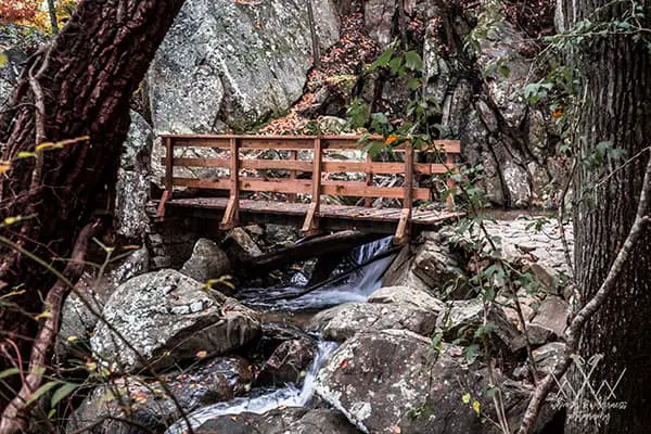
You can hear the falls now, and at .4 miles, the trail takes a sharp right turn and starts a short climb again. By this point you can see the falls if there has been enough recent rain, with water cascading over a gorge full of large boulders to the left.
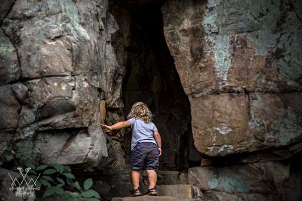
Pass a fallen tree in the middle of the trail and then turn to the left and go through a passage between two boulders, and you will see the falls, and the bridge that crosses over the top of the gorge.
When there has been enough rain, there is a swimming hole at the base of the falls that makes a great way to cool off when it’s hot outside, and offers kids and dogs some welcome water play. Parents beware: during high water, the pool can be over a foot deep so keep a close eye on toddlers, and while the pool is fairly calm, large rocks start underneath the bridge and the falls drop quickly on the other side.
This is a great place to stop and have a snack and splash around. From here you can head back the way you came, or continue over the bridge and up a short distance, to where the trail splits; to the left you can follow a slow ascent to make a .9 mile one-way trip to another parking pull-off on Ochs highway, or you can turn to the right and climb a steep set of stone steps that leads to a fun but narrow tunnel through the bluffs.
My recommendation is definitely to take the path to the right! The trail that continues on the left is extremely overgrown and doesn’t offer any views or additional waterfalls, and as you cannot (or at least should not) walk back to your car along Ochs Highway, you’ll be retracing your steps anyway.
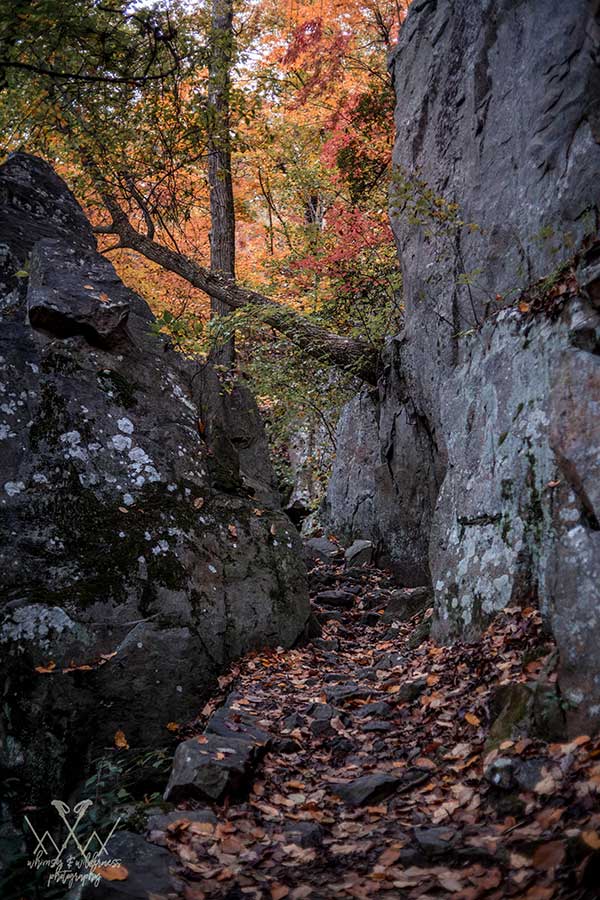
The path to the right on the other hand is where the best parts of the Glen Falls Trail can be found. At the top of the steps is a small and very narrow tunnel through some boulders, opening onto an overlook of the bridge and swimming hole you just came from.
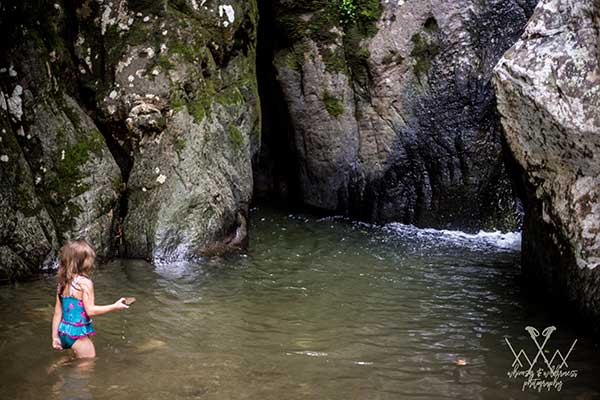
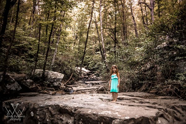
The trail continues past the overlook to the upper falls, with large rocks for a lunch or snack spot, and plenty of opportunities for water play. The trail parallels the creek until it connects to the road, but the real fun is rock hopping through the creek bed itself, especially when the water is low enough.
Retrace your steps back to the car for a one-mile circuit hike if you only went to the falls, or just under two miles if you took the path to the left of the steps.
What I love about Glen Falls
While this trail does not have the views that other trails on Lookout Mountain can boast, or the height of waterfalls found in other parts of Tennessee, there is still a lot of bang for your buck here. It’s a short trail which makes it great for young kids or for adults looking for something quick to squeeze in after work, and it has a lot of natural attractions to keep it interesting.
Even if it’s too cold to play in the water, the tunnel at the top of the steps leading to the upper falls always gets a great reaction from kids and adults alike, and when the water is low enough, rock scrambling in the creek bed above the falls is a great way of giving kids a chance at risky play.
I have taken my kids to this trail 2-3 times a month since we moved to Chattanooga because we have so much fun! The experience also changes so much based on local rainfall. We have seen the swimming hole so deep it nearly flows over the trail, and we have seen it so low it’s more of a giant sandbox with barely a puddle nestled into the corner of the rocks.
Same for the upper falls–some days we choose to sit and watch the water spill over the rocks, but we have also walked almost the length of the creek bed by scrambling up the dry rocks.
Have four legged hiking buddies? Dogs will love this as much as kids will! We have seen people hiking with dogs every time we’ve been out to Glen Falls, and they always get excited at the water–just keep them on leash, and be prepared for them to get wet and muddy!
Overall my favorite part of this trail is how much it packs into such a short trip. There is a total elevation gain of about 425 feet if you go to the top of the falls, and half of that is in the final ascent out of the trail.
Every time we go I am always surprised by how out of breath I am by the time we get back to the car–although that may be because my two year old usually wants to be carried during the last stretch. Even if you aren’t carrying an extra person the climb out will still get your heart rate up, and if you have kids or dogs with you should tire them out enough for a quiet drive home.
Special Precautions
- As mentioned above, the closer you get to the falls, the trail does drop off to the side. The drop starts shallow–only about six feet–but it does deepen, with a lot of large, sharp rocks in the falls gorge. There are also rocks and roots close to the trailhead. My two year old loves this trail and navigates it with ease, but on the trip back once he is tired from playing he stumbles a lot if he hasn’t asked to be carried. If you are hiking with toddlers I always recommend having a soft structured carrier with you (we use the Beco Toddler) in case your little ones need a lift on the way back up, and the area closest to the falls will definitely require close supervision of young children.
- Poison ivy is thick on this trail during the summer. Although it may be hot, pants are advised, or at least be prepared to stay away from the edges of the trail, and make sure everyone in your hiking party knows how to recognize it.
- I have not seen snakes on this trail (my kids are usually so rambunctious they scare the snakes away!), but I have heard of sightings from many other hikers. I have also seen yellow-jackets around the upper falls on nearly every trip out here, so be prepared with basic first aid for stings.
- As this trail is on land owned by the National Park Service, use is limited to daylight-hours only so plan to be off the trail by sunset or your car may be towed. There are no authorized campsites here, and unauthorized camping is strictly prohibited.
This is an awesome trail if you are looking for a “natural playground” for your kids, or if you want the elevation and terrain of trail hiking/trail running but don’t have the time to drive too far outside the city. This trail is also rarely crowded, making it perfect if you just want to spend a little bit of time enjoying nature.
Article and images by Stephanie Jacobson, originally written for TNhikingreport