I’ve been meaning to get down to twin falls and do a little hiking at Rock Island State Park for a while now and this weekend I finally made it. We really enjoyed the hike and the beautiful views around the falls. In this article I’ll tell you a little about the park itself and then a trail report for the trail we hiked, the downstream trail.
About Rock Island State Park
Rock Island State Park 883 acres of scenic views, waterfalls, and natural beauty in Warren and White Counties in middle Tennessee. The Caney Fork, Collins and Rocky River all converge in the park offering some excellent kayaking and canoeing opportunities for visitors to the park.
The Caney Fork Gorge is located in the park just below the Great Falls Dam, not far from where I hiked recently to see twin falls. This park is one of middle Tennessee’s hidden gems that you don’t hear about as much but I highly recommend going if you are in the area.
Directions
Rock Island State Park is located about 45 minutes south of I40 in Cookeville, TN. We came down Hwy 111 through Sparta, Tn then towards McMinnville on Hwy 70s.
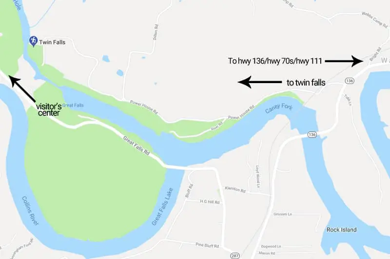
Just after crossing the Rocky River we took a right on Hwy 136, near a Dollar General.
Next we took a left on Hwy 287 which will lead you to the visitor’s center, although you’ll actually turn on Power House road to get to the downstream trail trailhead. See map below.
Directions to Rock Island State Park
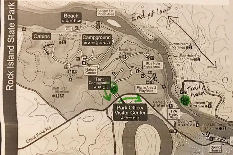
Hiking trails
- Eagle trail – 1.4 miles
- Moonshine trail – 1.0 miles
- Bluff trail – 1.7 miles
- Downstream trail – 1.7 miles
- Upstream trail – 1.0 miles
- Blue hole trail – .5 miles
- Collins River connector trail – 2 mile loop
- Old mill trail – 1.0 miles
Learn more about these hiking trails at Rock Island State Park here.
Camping
I have never been camping at this park, but they do have some facilities.
Main campground
Rates: $32 – $35
Rock Island State Park has 2 campgrounds for a total of 60 campsites. The main campground has 50 campsites, 20 of those are open year ’round. Each site at the here has 20,30, 50 amp electrical as well as water hookups.
Tent camping only campground
Rates: $21 – $25
This campground has 10 sites, all are tent camping only. This campground closes from Nov. 2 through March 15.
Now, the trail report for the downstream trail at Rock Island State Park in Tennessee:
Downstream trail
- Hike Length: 1.6 miles roundtrip
- Terrain: dirt, overgrown roots/sticks, rocky, steps, creeks
- Features: 80′ waterfall, dozens of smaller falls, views of the river, high cliffs
- Difficulty: moderate
How to get to the trailhead
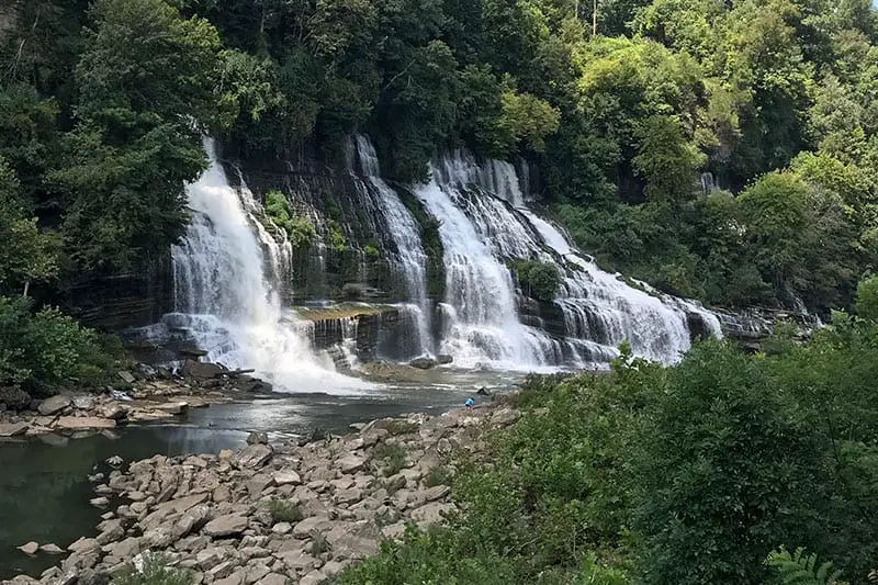
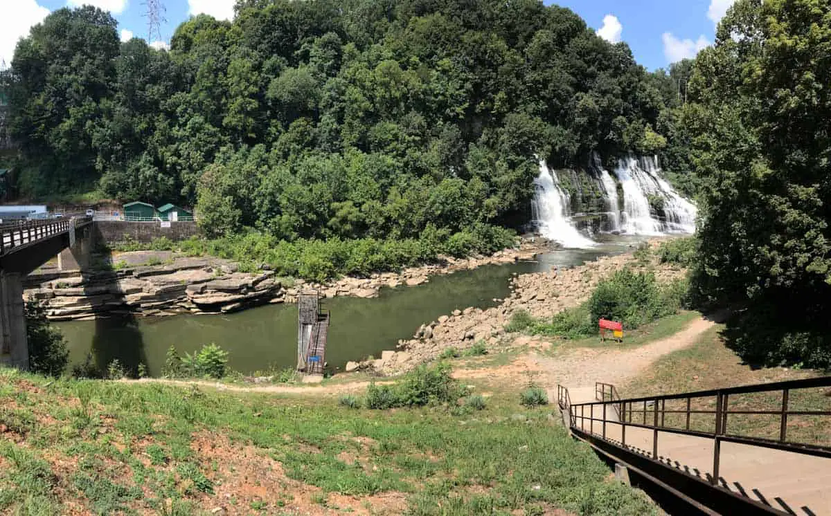
Coming in from the north on highway 136, you’ll take a right on Power House Rd. then follow it until it dead ends at the parking lot right beside twin falls. The trail head is just down a couple of flight of stairs. There’s a great spot to look at the falls for a few minutes and get a couple of pictures before you start your hike.
Directions to the twin falls trailhead
About the hike
You don’t really hike to the falls, because you start at the falls. If you’re running short of time you can just go down the stairs I showed you, get a quick view of the falls and save that hike for another time.
Or you can continue on the downstream trail that follows along the Caney Fork and get in a nice little 1.6 mile hike through the woods and along the bluffs over the river.
You’ll find plenty of waterfall views along the trail. It seems like there were waterfalls on the other side of the river almost the whole way, like one really long water fall. You will pass by Twin Falls, Little Falls, and several other spots with water trickling off the cliff in varying strengths. Either way it was a nice view.
It took us about an hour and a half to complete the hike, but we really weren’t in a hurry and took our time. We even went the wrong way for a little while trying to go around the loop.
Tip: as you’re going around the loop always stay to the left even if the right looks like the right way.
Watch out for snakes
As we were going around the loop we came upon a juvenile Northern Copperhead crossing our path. I tried to get a picture of his head and whole body to confirm but he was winding up around a little plant so I never really got a good view. 99% sure it was a copperhead though.
Who can do this hike?
It’s a moderate hike, there are steps in a few places as well as a few creeks to cross.
This hike should be ok for people in average shape with no physical disabilities, and above. As I mentioned there are several stairs to contend with so hiking strollers are out. You might get by with a good carrier backpack.
People with disabilities or who are in very poor shape should probably not attempt this hike, especially on a hot day. Any casual hiker should be fine. Just keep in mind it is a very rocky/rooty terrain in many places.
Use caution
This area is not far downstream from Great Falls Dam and the water here can flood without warning and there are swift currents in various places. Use extreme caution if you go down in the gorge. Swimming in this area is prohibited, but we saw several people swimming and jumping off of cliffs.